 The most basic step in fieldwork is locating a site of interest
on a map. In the United States, geologists and most other scientists who work in
the field use topographic maps published by the U.S. Geological Survey. These
maps show elevation as well as areal location. They also allow a point on the map
to be expressed as latitude and longitude, universal grid coordinates, or section,
township and range.
The most basic step in fieldwork is locating a site of interest
on a map. In the United States, geologists and most other scientists who work in
the field use topographic maps published by the U.S. Geological Survey. These
maps show elevation as well as areal location. They also allow a point on the map
to be expressed as latitude and longitude, universal grid coordinates, or section,
township and range.
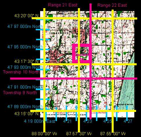
This example shows the location of the study quarry at Lime Kiln Park, Grafton, on a
U.S. Geological Survey map named the Cedarburg 7.5 minute quadrangle. The map location can
be specified in three ways:
- 43 degrees 18 minutes 15 seconds north latitude, 87 degrees 57 minutes 30 seconds west longitude
- Grid coordinates (Universal Transverse Mercator - UTM) Zone 16: 4794800mN 423800mE
- SE1/4 of the NW1/4 of section 25, Township 10 North, Range 21 East
|
