When was Aztalan first discovered?
Aztalan was first discovered by Europeans in the fall of 1835 by early Wisconsin Territory settler Timothy Johnson of Watertown. Upon hearing stories of the site, Judge Nathaniel Hyer, a Milwaukee settler, visited. His description, the first at-length published account of Aztalan, appeared in the Milwaukee Advertiser, Volume One, Number 29 on Saturday, February 25th, 1837. In this account, Judge Hyer also produced the first rudimentary map of the site. Although his written account and illustrations are not precise, they did capture the general features and layout of Aztalan.
How did Aztalan get its name?
It was Judge Hyer who first gave Aztalan its name. The name Aztalan comes from the mistaken idea, prevalent in the early nineteenth century, that the site may have been the northern place of origin of the Aztecs of Mexico as mentioned in their legends and oral traditions. Judge Hyer related Aztalan to the Aztecs based on the resemblance he saw between its mounds and the Aztec pyramids; he was heavily influenced by the writings and observations of Prussian naturalist and scientific traveler Baron Alexander Von Humboldt (1769-1859), who wrote about his travels in Mexico. Humboldt stated that the Aztec's original homeland was to the north and was called Aztalan. Hyer's early written account of Aztalan was eventually widely-published in newspapers, magazines, and journals in the United States, helping to fuel great public interest in the site and its antiquities. This led to a flood of relic hunters at Aztalan who damaged the mounds while digging for artifacts. In addition, this interest led to many questions about who built Aztalan and why. Native Americans of the region at the time of Aztalan's discovery made no such mound structures. This became a subject of great speculation and mystery which would lead to a series of erroneous observations about the nature of the site of Aztalan itself. The most common proposition pertained to the nature of the stockade that had surrounded the site. Judge Hyer claimed that there was a foundation of a "brick wall" that had once surrounded the site. The first recorded digging at the site was conducted by W.T. Sterling in 1838. Sterling excavated through a portion of still visible stockade with a spade and pickaxe, and concluded that the wall was made of clay mortar mixed with grasses -- not brick, as previously speculated and reported by Judge Hyer. Today we refer to the burned wattle and daub as "Aztalan brick."
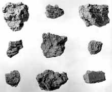
Figure 16. "Aztalan Brick" - Dr. Samuel A. Barrett Excavations
MPM Photo Collection # 70490
In 1838, President Van Buren was asked to withdraw the public sale of the section of land where Aztalan is located because of its potential archaeological significance. The request was denied and the federal government sold the land for $22. Agricultural cultivation of the land began soon after.
Increase A. Lapham and Aztalan
During the late 1830s and 1840s, the area was cultivated in some areas and artifacts were heavily collected by amateur collectors. It was not until 1850 that Increase A. Lapham investigated the major undisturbed portion of the site. Lapham, a land surveyor by trade, had become interested in Indian mounds as he laid out streets along the bluffs and rivers of the then new community of Milwaukee in 1836. With the support of the American Antiquarian Society, he spent several years mapping and examining numerous Indian mound groups throughout the southern half of the State of Wisconsin. Lapham carefully mapped the site and conducted some preliminary excavations, describing and mapping several features that Hyer had overlooked. In 1855, the results of Lapham's years of research were published by the Smithsonian Institution in a landmark book entitled The Antiquities of Wisconsin, as Surveyed and Described. This was the first published book on Wisconsin archaeology. Despite efforts to preserve the site, Aztalan was left to late nineteenth and early twentieth century relic hunters, and the farmer's plow that smoothed over many of the distinctive archaeological features noted by Lapham and others. Lapham's research and detailed maps have proven instrumental in the reconstruction of Aztalan.
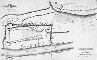
Figure 17. Aztalan Map by Dr. I. A. Lapham 1850 MPM Photo Collection # 7043a
Dr. Samuel A. Barrett
Former Milwaukee Public Museum director, curator, and field anthropologist Dr. Samuel A. Barrett was born on November 12, 1879 in Conway, Arkansas. Barrett was introduced to the field of anthropology through the influences of Frederic Ward Putnam and Franz Boas. Putnam was the Chairman of the Department of Anthropology at the University of California, Berkeley, where Samuel Barrett received his Ph.D. Franz Boas was an influential professor of his at Columbia University. His early interests in anthropology included Native American baskets, especially Pomo Indian baskets, and excavations in California at the Putah Creek burial site and the Emeryville shell mound.
Barrett started his career at the Milwaukee Public Museum as a curator in the Department of Anthropology in 1909. Later, he served as Director of the Milwaukee Public Museum from 1921 to 1939. While at the Milwaukee Public Museum, Barrett figured prominently in the development of professional archaeology of Wisconsin. He was the first professionally trained archaeologist with a Ph.D. to work in the state of Wisconsin, and he introduced technical methods which were superior to any employed at that time in the region. He also helped to stimulate interest in neighboring areas, resulting in intensified archaeological programs evolving in Michigan, Illinois, Iowa, and Minnesota.
Samuel Barrett's first published monograph on Wisconsin archaeology, co-written by E.W. Hawkes, was The Kratz Creek Mound Group published in 1919. Barrett's work was seminal in the study of burial mounds in the state of Wisconsin. He demonstrated that at least two different cultures were involved with mound construction on one site with the presence of three different mound types: the conical, linear, and effigy mounds. Barrett also broke new ground in excavation methods by paying close attention to the internal structuring and layering of mound soils. These methods and techniques would serve him well in his investigations at Aztalan.
Samuel A. Barrett's most noted archaeological work was the first professional excavation of the Aztalan site. The first survey and excavations began on July 10, 1919, and continued through September 30 of that year. Further excavations were conducted from June until September of 1920, and again for a brief period in June and July of 1932. Barrett's findings are painstakingly described in his monumental study entitled Ancient Aztalan, published by the Museum in 1933.
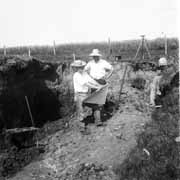
Figure 18. Dr. Samuel A. Barrett (Center) Aztalan Excavation of 1919
MPM Photo Collection # 32081
Barrett and the MPM Excavations of Aztalan
The first scientific and systematic excavations of any archaeological site in the State of Wisconsin were conducted at Aztalan in 1919 by Samuel Barrett and the Milwaukee Public Museum. Barrett was first taken to Aztalan by George A. West, a founding father of the Wisconsin Archaeological Society, in May of 1919. Mr. West's keen interest in Wisconsin archaeology had many times taken him to Aztalan, and he had frequently described it to Dr. Barrett. His visit with George West inspired Barrett to excavate the site that same summer. The field excavations conducted by Barrett focused on several key aspects into the true nature of the Aztalan enclosure walls. While excavating, Barrett discovered a series of post molds which later led to the reconstruction of the stockade line, including watch towers or bastions constructed of upright poles covered with clay plaster mixed with grass in the wattle and daub technique. Through the excavation of other portions of Aztalan, Barrett discovered the remains of small houses, thousands of pieces of human and animal bone, food remains, storage and refuse pits, burials, chipped stone tools such as projectile points and stone knives, bone tools, and several different varieties of Woodland and Mississippian pottery sherds.
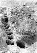
Figure 19. Excavated Stockade Post Molds - Aztalan
MPM Photo Collection # 60458
Dr. Samuel A. Barrett Excavations 1919.
Barrett also investigated the great southwest platform mound and discovered that it was built in a series of stages. He also excavated mounds on the ridge northwest of the main enclosure and found that they were not burial mounds as originally thought, but mounds that contained large ceremonial wooden posts. Barrett suggested that these mounds with large wooden posts might be associated with the ethnographically-known Green Corn Ceremonies held by modern Native Americans of the Southeast United States, which included the raising of such large ceremonial posts. Based on the cultural artifacts found in these excavations, Barrett concluded correctly that Aztalan was associated with the Mississippian cultures of the American Bottoms of Cahokia and the southeast.
Barrett conjectured that cannibalism was a major part of the Mississippian diet at Aztalan, based on the numerous butchered, broken, and burned human bones in refuse areas, fire pits, and the natural knoll area of the site in the southeast corner of the enclosure. Warfare and cannibalism are among the most heavily-debated topics of archaeological research and interpretation, and have been an area of great interest at Aztalan. Since Barrett's initial excavations, it has been suggested that warfare and cannibalism were important organizing factors at Aztalan and in Mississippian societies as a whole, and may have, in fact, lead to the eventual disintegration of the society at Aztalan itself. Most of the evidence at Aztalan seems to suggest that some bones were most likely processed during mortuary practices that were common during Late Woodland and Mississippian occupations and therefore represent the normal mortuary rituals. If they do represent cannibalism, several ethnographic analogies suggest it is possible that members of the society or war captives were consumed as part of ritualistic sacrifices.
Wisconsin Archaeological Society dedication
On October 20, 1928, the Wisconsin Archaeological Society met at Aztalan to unveil a commemorative sign recognizing the site's rich history. The bronze plaque, attached to a large granite boulder, has the following inscription:
Site of the famous prehistoric Indian stockade-protected village known as Aztalan. First described by N.F. Hyer, in the Milwaukee Advertiser in January, 1837. Described by Dr. Increase A. Lapham in the "Antiquities of Wisconsin" in 1855. Explored by the Milwaukee Public Museum in 1919-21. Purchased by the citizens of Jefferson County in 1922, and presented to the Wisconsin Archaeological Society. Marked by the Wisconsin Archaeological Society in 1927.
Several hundred people attended the dedication ceremony in support of the preservation of the site, and appropriate addresses were made by members of the Wisconsin State Historical Society and the Wisconsin Archaeological Society to commemorate the site's purchase and designation as a park.
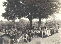
Figure 21. MPM Photo Collection #60463
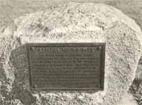
Figure 20. MPM Photo Collection #404020
A Timeline of More Recent Archaeological Activities
1948: The Wisconsin Department of Natural Resources purchases 120 acres of the Aztalan site area. The Wisconsin Archaeological Society and the Lake Mills-Aztalan Historical Society donate the lands in their possession to the state. The State of Wisconsin plans to develop the land into a state park.
1949-1952: The Wisconsin Archaeological Survey (a group of professional archaeologists) conduct further excavations at Aztalan to increase scientific knowledge of the site and to provide technical information for various restoration projects by the Wisconsin Department of Natural Resources. Included in the work is the excavation of additional houses, entrances to the site, and the precise location of stockade lines that are used in the stockade restoration. The results of these investigations are published in the Wisconsin Archaeologist (Baerreis 1958). The development of radiocarbon dating helps establish a time frame of occupation for Aztalan, around A.D. 900-1300.
1952: Aztalan State Park is opened to the Public and encompasses 172 acres.
1962-1968: Dr. Joan E. Freeman conducts excavations for the State Historical Society of Wisconsin within portions of the residential area of the site. Dr. Freeman's excavations provide more archaeological remains for interpretation and display. She focuses on housing structures to help better determine their form.
1964: Aztalan becomes a National Landmark.
1966: Aztalan is listed on the National Register of Historic Places.
1976-1987: Dr. Lynne Goldstein of the University of Wisconsin-Milwaukee (UWM) begins the "Crawfish and Rock River Archaeological Project," which later becomes the "Southeastern Wisconsin Archaeological Project." This was the beginning of the first systematic archaeological survey of the region surrounding Aztalan, and places the site in a broader context. Goldstein and UWM archaeological students conduct shovel tests and excavations across the whole site to try to answer questions about site organization and development. By 1987, the project is complete with more than 500 new archaeological sites discovered. Interestingly, few of them relate to Aztalan or share the same kinds of artifacts.
1984: The University of Wisconsin-Milwaukee conducts archaeological excavations in habitation areas of Aztalan, which includes a large garbage midden accumulation. UWM archaeologist John Richards analyzed the contents of eight feet of neatly deposited layers of cultural remains that spanned several hundred years of site occupation, from a small Woodland period farming village to the sudden emergence of the Mississippians.
1994-1995: Dr. Lynne Goldstein and UWM students excavate approximately 200 tree stumps, which threaten archaeological features and need to be removed from the open area of the site within the stockade.
1996: The area south of the northwest mound is excavated by Dr. Lynn Goldstein and UWM students. The area exhibited 70 oval depressions that became visible when this area was mowed. It was discovered that each oval feature was a pit about two meters wide by two meters deep and was determined to be ceremonial in nature. The pits were on a sculptured, tiered surface.
2001-2002: In 1996, Dr. Goldstein left UWM to become the head of the Department of Anthropology at Michigan State University and began to study different aspects of the site such as the agricultural fields to the north of the enclosure area, the area to the south of the enclosure, and the area across the Crawfish River adjacent to the enclosure first described by T.M.N.Lewis and Barrett in 1929. She brought a fieldschool out in 2001 to conduct this targeted fieldwork and also began a project of compiling all known information about the site. This synthesis and fieldwork was funded by the National Science Foundation.
2003: Electromagnetic conductivity remote sensing by the Wisconsin Historical Society's Office of the State Archaeologist and Earth Information Technologies Inc. reveal that some archaeological features remain in the southwest corner of the site.